Understanding the Native Vegetation Regulatory Map and Biovidersity Values Map

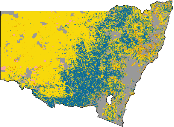
The Native Vegetation Regulatory Map (NVR Map) on rural land zones in NSW:
The NSW Local Land Services Act 2013 (LLS Act) commenced on 25 August 2017. This legislation is a critical framework for managing and regulating native vegetation on rural land across New South Wales. Under the LLS Act, the NSW Department of Climate Change, Energy, the Environment and Water (DCCEEW) maintains a Native Vegetation Regulatory Map (NVR Map) to clarify land categorisations for landholders and industry stakeholders. The role of Local Land Services is to provide essential guidance, approvals, and administration regarding the LLS Act. Please note: The NVR Map and the LLS Act apply specifically to rural land zones (including RU1, RU2, RU3, RU4, and RU6) within New South Wales (but not RU5).
The NVR Map comprises of six "land categories" that define where vegetation clearing is regulated, unregulated, or restricted or if the LLS Act doesn't apply. Because lawful clearing methods and distance thresholds vary across these six categories, the NVR Map serves as a vital visual tool for identifying the rules applicable to specific locations. In August 2026 the NVR Map was finalized for all of NSW (except for Temora and Bland LGA's) the NVR Map can be viewed here: https://www.lmbc.nsw.gov.au/Maps/index.html?viewer=NVRMap. Landholders can use this tool to search their properties and view the proposed land categorisations.
The NVR Map is now legally binding, meaning the NSW Government considers these categories accurate and landholders must comply with the associated regulations. NSW LMAS can assist you in navigating native vegetation rules to ensure any clearing remains lawful and compliant, we can also assist if you dispute the proposed land categorisation.
The Biodiversity Values Map (BV Map) identifies areas of high-value biodiversity throughout NSW. BV Mapping is a trigger when proposing a development where environmental considerations must be addressed prior to altering vegetation. You can view the map here: https://www.lmbc.nsw.gov.au/Maps/index.html?viewer=BOSETMap. While specific biodiversity details are not always public, property owners can request more detailed data manually. NSW LMAS is available to help you navigate this request process or can manage the inquiry on your behalf. The intricacies of the BV Map can significantly influence property management, particularly if you are seeking Council approval for a development. Applicability can vary based on specific approvals, credits, or zoning. It is critical to note that removing vegetation within high-value biodiversity areas without proper authorisation carries severe penalties and may result in mandatory replanting orders, we can assist you in the process.
The Biodiversity Values Map and its application to all land zones in NSW:
No map is 100% accurate. The way that the NVR map were created were at the high level suburb scale, which then means that the property-scale definition is missed. NSW LMAS provides expert advice on review processes and can guide you through applications to amend maps where inaccuracies exist. This may involve engaging an ecologist or environmental consultant for a site inspection. While some categories, such as wetlands, are typically well-defined, others—like threatened species habitats—may require closer scrutiny to confirm accuracy, which is where we can assist you.
Accuracy of NVR and BV Maps: